
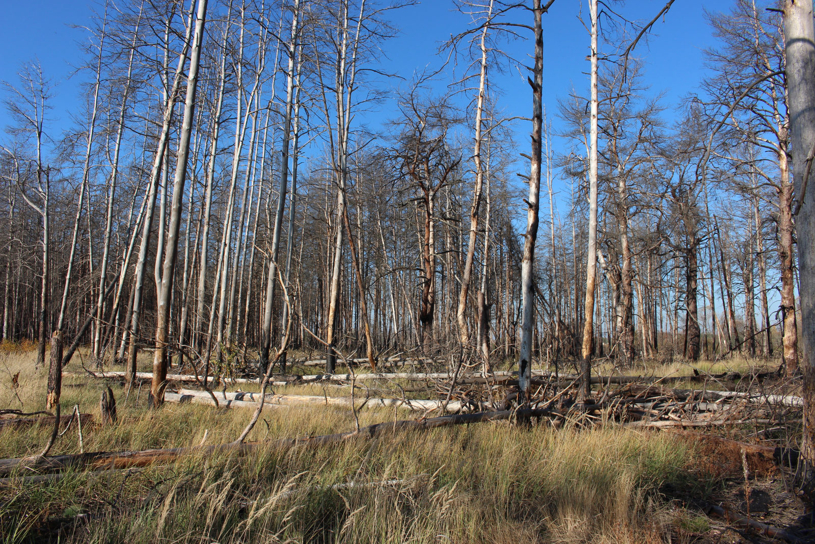
Pinus sylvestris Inside the Red Forest in the Chernobyl Exclusion Zone — a four to six square kilometre patch of regrowth where the original Scots Pines died within weeks of the April 1986 reactor explosion. The new pines carry measurable radiation damage at the cellular level. Photograph: ArticCynda, October 2019 · CC BY-SA 4.0 · sourced from Wikimedia Commons.
The same patch of northern Ukraine — eight months before the explosion, and thirty-nine years after.
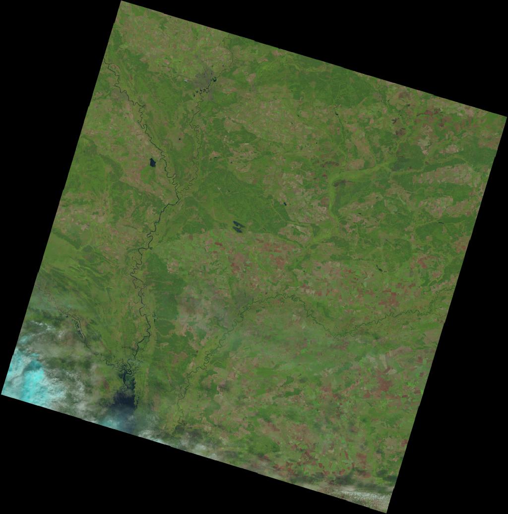

What to look for. The crimson dot marks the Chernobyl plant — Reactor 4 and the Red Forest sit immediately west of it. The 30 km Exclusion Zone extends roughly fifteen percent of the image radius in every direction from that dot, encompassing the Pripyat River and the abandoned town. The large dark body of water in the lower-left is the Kyiv Reservoir, about 25 km south of the plant.
25 August 1985 — Before A Landsat 5 view of northern Ukraine eight months before the reactor explosion. The pine forest west of Reactor 4 is intact. Fifty thousand people are living in Pripyat. Children are walking to school past the pines.
5 September 2024 — After The same coordinates thirty-nine years on. The Exclusion Zone has become a state-managed biosphere reserve; the Red Forest has regrown — though the new trees carry radiation damage at the cellular level. In 2022 military tanks crossed land that had stood undisturbed for thirty-six years.
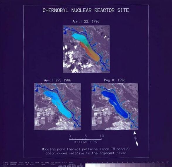
Imagery: NASA / USGS · Landsat 5 (1985) and Landsat 8 (2024) Collection 2 Level-2 · Path 181, Row 024 · same orbital pass, thirty-nine years apart. Public domain. Sourced via USGS EarthExplorer. The historic Landsat 5 thermal scan of 29 April 1986 — three days after the explosion — is preserved inline within "The act" chapter below.
Pinus sylvestris
Pinus sylvestris is one of Europe's most widespread conifers — billions of trees, from Spain to Siberia, no risk of extinction. But on a patch of land four to six square kilometres in size, immediately west of Chernobyl's Reactor 4, this ordinary species became something else: a living instrument for measuring what happens when a forest absorbs the fallout of the worst nuclear accident in history, and then, thirty-six years later, the trenches and tank tracks of renewed military activity in February–March 2022.
Quick facts
- Family
- Pinaceae (pine family) — one of the most widespread conifer families in the northern hemisphere
- Described to science
- 1753, by Carl Linnaeus, in Species Plantarum
- IUCN status
- Least Concern globally (assessed 2017); the Red Forest population is one-of-a-kind on Earth
- This case study
- The Red Forest — approximately 4 – 6 km² of pine immediately west of Chernobyl Reactor 4 (~51.39°N, 30.05°E)
- Habitat
- Boreal pine forest on sandy Polesia soils at ~150 m elevation — a long-cooled glacial outwash plain that the species has occupied for thousands of years
- Habitat protection
- Chernobyl Exclusion Zone (~2,600 km²); declared a State Biosphere Reserve by Ukraine in 2016
- What touched it
- Caesium-137 and strontium-90 fallout from the April 1986 reactor explosion — half-lives measured in centuries
- Documented effects
- Chromosome aberrations, threefold mutation rates, persistent oxidative stress at the cellular level — confirmed by Geras'kin et al. (2017) and Steen & Mousseau (2025)
- Renewed threat
- February–March 2022: military activity at the Chernobyl site disturbed contaminated soil, dug trenches, and released radioactive dust into the air
Three layers of the same landscape
The Polesia region of northern Ukraine was once a quiet patchwork: pine forests on sandy soils, peat bogs in the lowlands, villages of timber houses scattered between. Scots Pines grew everywhere — slow, tall, resilient trees adapted to thin soils and cold winters. The Pripyat River wound through the landscape.
In the 1970s, the Soviet Union built a town called Pripyat to house workers at the new V.I. Lenin Nuclear Power Plant, a few kilometres south. By the early 1980s, around fifty thousand people lived there. Children walked to school past the pine woods. Fishermen worked the cooling pond.
The forests, the river, and the reactor existed together — three layers of the same landscape, each invisible to the others.
The forest that turned red overnight
At 1:23 am on 26 April 1986, reactor 4 of the Chernobyl Nuclear Power Plant exploded during a safety test. A plume of radioactive material rose nearly a kilometre into the atmosphere and drifted across Europe. The forest immediately downwind absorbed the heaviest fallout.
Within hours, the pine needles began to die. Within days, the trees turned a rusty red-brown. Soviet authorities evacuated Pripyat on 27 April. The 'Red Forest' — roughly four to six square kilometres of dying pines — was bulldozed and buried in trenches to limit further contamination.
A thirty-kilometre Exclusion Zone was established, encompassing more than 2,600 square kilometres of forest, wetland, and abandoned villages. Approximately 350,000 people were displaced.
An accidental nature reserve, interrupted
Four decades on, the Exclusion Zone has become an accidental nature reserve. In the absence of humans, wolves, lynx, wild boar, and Przewalski's horses have flourished. New pines have grown where the bulldozed Red Forest used to stand — though they remain visibly stressed, marked by radiation damage at the cellular level.
In February–March 2022, the Chernobyl site again came under military activity — the first such activity since 1986. Trenches dug into contaminated soil released radioactive dust into the air; tanks crossed land that had remained undisturbed for thirty-six years.
The forest still stands. The trees still grow, slowly, in soil that holds caesium and strontium with half-lives measured in centuries.
Timeline
- 26 April 1986Reactor 4 explosion at Chernobyl, 1:23 am local time
- 27 April 1986Evacuation of Pripyat — ~50,000 residents
- May 1986Red Forest pines die and turn rust-red
- Summer 1986Red Forest bulldozed and buried in trenches; 30 km Exclusion Zone established
- 2000The final operational reactor at Chernobyl shut down
- 2016Exclusion Zone declared a State Biosphere Reserve; New Safe Confinement structure installed over reactor 4
- Feb – Mar 2022Renewed military activity at the Chernobyl site (24 Feb – 31 Mar)
Incidents on the map
| Date | Place | Description | Source |
|---|---|---|---|
| 26 Apr 1986 | Reactor 4 (51.39°N, 30.10°E) | Explosion and radioactive release | IAEA reports |
| Spring 1986 | Red Forest area (west of reactor) | Pines die and are buried in trenches | Chernobyl Forum, 2006 |
| 27 Apr 1986 | Pripyat (51.40°N, 30.06°E) | Evacuation of approximately 50,000 residents | Soviet government records |
| 24 Feb 2022 | Chernobyl plant area | Renewed military activity begins at the site | IAEA / Ukrainian government |
| Mar 2022 | Exclusion Zone forests | Wildfires in the Exclusion Zone forests | Ukrainian Ministry of Environment |
| 31 Mar 2022 | Chernobyl plant area | Military activity at the site ends | IAEA reports |
Key statistics
Sources and citations 7 references ›
- Chernobyl Forum (2006). "Chernobyl's Legacy: Health, Environmental and Socio-Economic Impacts." IAEA / WHO / UNDP.
- Mousseau, T.A. & Møller, A.P. (2014). "Genetic and Ecological Studies of Animals in Chernobyl and Fukushima." Journal of Heredity.
- Geras'kin, S., et al. (2017). "Genetic, oxidative and epigenetic effects of chronic low-dose radiation on Scots pine in the Chernobyl Exclusion Zone." Scientific Reports 7, 43009.
- Steen, T.Y. & Mousseau, T.A. (2025). Synthesis of multi-decadal Scots Pine studies in the Chernobyl Exclusion Zone. Environmental and Experimental Botany.
- IAEA (2022 – 2024). Statements on Chernobyl during the 2022 period of military activity at the site.
- Ukrainian Ministry of Environmental Protection records.
- NASA Earth Observatory satellite analyses of the Chernobyl Exclusion Zone.