
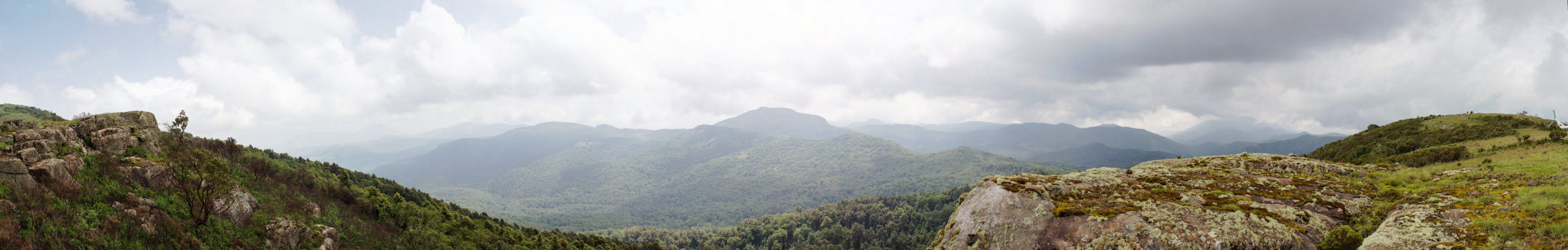
Imatong Mountains From the top of Mount Kinyeti (3,187 m), South Sudan's highest peak, looking out across the cloud-forested slopes that hold Impatiens imatongensis. The view is from 2011, the year of the country's independence and two years before the civil war began. Photograph: AIMikhin, July 2011 · CC BY-SA 3.0 · sourced from Wikimedia Commons.
The same Imatong landscape, eleven years apart. Two days before the civil war began — and the same satellite track, the same dry season, after a decade in which almost no one was watching.
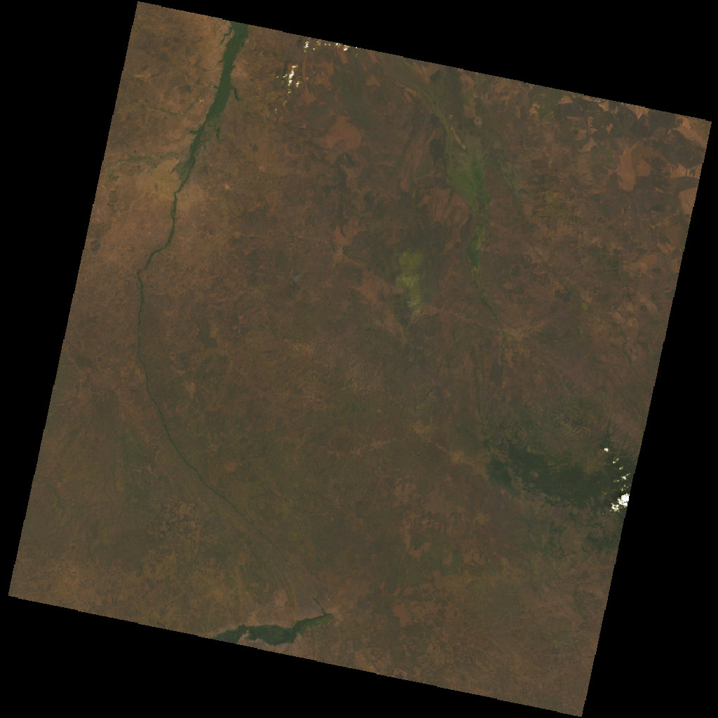
13 December 2013 — Before Landsat 8, Path 172 / Row 057, dry season. Two days before fighting broke out in Juba. The dark green block in the upper right is the Imatong massif — the cloud forest and montane grassland of Mount Kinyeti, the Imatong Balsam's only home. The green threads tracing the lowlands are riparian forest along the dry-season rivers. The brown is open savannah waiting for the rains.
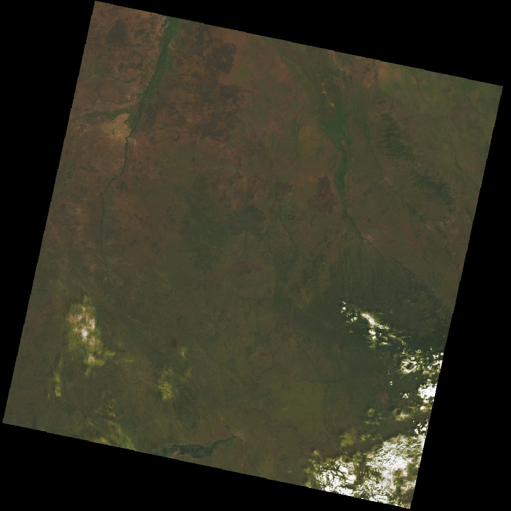
5 February 2025 — After Landsat 9, same orbital path, same dry season. Eleven years on. The differences are small and patchy — that is precisely the story. South Sudan's war did not bomb the Imatongs. It removed the rangers, the botanists and the protected-area surveys that would have noticed the slow attrition: charcoal production around the lower slopes, refugee-settlement expansion along the Ugandan border, the disappearance of small clearings where Impatiens imatongensis grew.
Imagery — 13 December 2013: NASA / USGS · Landsat 8 OLI Collection 2 Level-2 · Path 172, Row 057. 5 February 2025: NASA / USGS · Landsat 9 OLI Collection 2 Level-2 · same Path and Row. Both public domain. Sourced via the Microsoft Planetary Computer mirror of the USGS Landsat archive. The Imatong Forest Reserve has been imaged continuously from orbit since 1972, even when no human researchers could safely visit.
Impatiens imatongensis
Impatiens imatongensis is a small pink-flowered annual found in cool, damp clearings on a single mountain range that straddles the border between South Sudan and Uganda. It has no second home on Earth. For most of the last decade, the civil war that engulfed its country also engulfed the science of watching it: the rangers withdrew, the botanists evacuated, the field surveys stopped. The plant is presumed to be still there. Nobody can quite say.
Quick facts
- Family
- Balsaminaceae — the touch-me-not family, ~1,000 species worldwide, with notable concentrations of endemics on African mountains
- Described to science
- 1947, by Eric Milne-Redhead at Kew, from material collected in the Imatongs in the 1930s
- IUCN status
- Endangered — last formally assessed before 2000; no reassessment has been possible since the 2013 civil war began
- Wild population
- Unknown. Suspected to persist in cool, wet clearings between 2,200 and 3,000 m elevation on the Imatong massif
- Habitat
- Cloud forest and montane grassland on the slopes of Mount Kinyeti (3,187 m), South Sudan's highest peak; the species' range likely extends a short distance into Uganda
- Habitat protection
- Imatong Forest Reserve (~1,000 km²), established 1952 under British colonial administration; nominally protected but barely monitored since 2013
- Insurance population
- None known. Seed-bank collections from the Imatongs are extremely limited; no botanic garden is known to be cultivating this species
- What touched it
- The South Sudanese civil war (December 2013 – present): mass displacement, the collapse of formal conservation, and unregulated charcoal production around refugee settlements
- Primary threat today
- The same as it was a decade ago, only less visible: continued deforestation on the lower slopes, climate change at the upper edges, and a near-total absence of botanists who can verify either
Islands in the sky
The Imatong Mountains rise from the South Sudanese plains like islands in the sky. Mount Kinyeti, the country's highest peak at 3,187 metres, sits at their centre. The mountains catch moisture the surrounding savannah does not — cloud forest, montane grassland, and bamboo zones grow on their slopes. Many of the plants found here grow nowhere else: small balsams, ground orchids, dwarf shrubs, a handful of endemic ferns.
The Imatong Forest Reserve, established under British colonial rule in 1952, protected roughly 1,000 square kilometres of this landscape. Through Sudan's long civil wars the reserve was nominally protected but rarely visited by botanists. The Imatong Balsam — a small pink-flowered plant of forest clearings — was one of the species that survived almost unwatched.
The forgotten war
South Sudan became the world's newest country on 9 July 2011. Independence brought brief optimism. In December 2013, just thirty months later, fighting broke out in Juba between forces loyal to President Salva Kiir and former Vice President Riek Machar. Within weeks, the violence had spread to most of the country. An estimated 382,900 excess deaths were recorded between 2013 and 2018; four million people were displaced.
Conservation effectively stopped. The Imatong Forest Reserve, like many protected areas, became impossible to monitor. Deforestation accelerated — charcoal production, refugee settlements, and uncontrolled logging took advantage of the absence of state authority.
The Imatong Balsam continued to grow, or to disappear, with no one to count which.
A flower no one watched fade
A revitalised peace agreement was signed in 2018, and a transitional government formed in 2020. Conservation researchers have begun cautiously returning to South Sudan's protected areas, but the Imatong Mountains remain difficult to access. Satellite imagery shows continued forest loss on the lower slopes, particularly along the Ugandan border.
The Imatong Balsam was last formally assessed by the IUCN as Endangered; its actual current status is unknown. It may be locally common where it survives, or locally extinct on slopes that have been deforested.
This is the quiet cost of conflict: not destruction with a date and a place, but disappearance with no one to record it. A flower no one watched fade.
Timeline
- 1947Impatiens imatongensis described to science by Eric Milne-Redhead at Kew
- 1952Imatong Forest Reserve established under British colonial rule
- 2005Comprehensive Peace Agreement ends Sudan's civil war
- 9 July 2011South Sudan declares independence
- 15 December 2013Civil war breaks out in Juba
- 2014 – 2018Mass displacement; conservation access to the Imatong Mountains lost
- 2018Revitalised peace agreement signed
- 2020Transitional government formed
- 2024Cautious resumption of conservation research begins in parts of the country
Incidents on the map
| Date | Place | Description | Source |
|---|---|---|---|
| Dec 2013 | Juba (4.85°N, 31.58°E) | Initial outbreak of civil war | UN OCHA |
| 2014 – 2015 | Imatong Mountains (3.95°N, 32.85°E) | Conservation access lost | IUCN bulletin |
| 2015 | Bor (6.19°N, 31.55°E) | Wider forest reserve disruption | UN OCHA / ACAPS |
| 2015 – 2018 | Ugandan border, southern Imatong slopes | Refugee movements impacting forest cover | UNHCR |
| 2020+ | Mount Kinyeti area | Cautious satellite-based reassessment begins | Global Forest Watch |
Key statistics
Sources and citations 7 references ›
- Checchi, F., et al. (2019). "Estimates of crisis-attributable mortality in South Sudan, December 2013 – April 2018." London School of Hygiene & Tropical Medicine.
- UN Office for the Coordination of Humanitarian Affairs (OCHA). South Sudan situation reports, 2013 – present.
- IUCN Red List. Impatiens imatongensis species assessment.
- Global Forest Watch. South Sudan deforestation data, 2010 – present.
- BGCI / Fauna & Flora International. Conservation status reports on the Imatong Mountains.
- NASA / USGS (2013). Landsat 8 OLI Collection 2 Level-2 surface reflectance scene of the Imatong Mountains, Path 172 / Row 057, 13 December 2013. Public domain. Sourced via the Microsoft Planetary Computer mirror of the USGS Landsat archive.
- NASA / USGS (2025). Landsat 9 OLI Collection 2 Level-2 surface reflectance scene of the Imatong Mountains, Path 172 / Row 057, 5 February 2025. Public domain. Sourced via the Microsoft Planetary Computer mirror of the USGS Landsat archive.